Have you ever wondered how to protect your home from the devastating effects of high winds? Look no further than wind zone maps. These essential tools provide valuable information about wind speeds and gusts in specific areas, helping homeowners make informed decisions for their safety. In this article Discover Your Mobile Home Wind Zone we will discuss all things you need to consider when figuring out your wind zone.
Discover Your Mobile Home Wind Zone
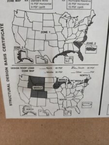
Wind zone maps come in different categories, such as Wind Zone II and Wind Zone III, each indicating varying levels of risk. By understanding these maps, individuals can take proactive measures to safeguard their homes and ensure the well-being of their families. This will help you to discover your mobile home wind zone.

Moreover, wind zone maps play a crucial role in determining building codes and regulations. They enhance structural resilience by providing guidelines that help architects and engineers construct homes capable of withstanding powerful winds.
So whether you’re planning to build a new home or looking to fortify your existing one, delving into the world of wind zone maps is a wise move. Let’s explore this vital tool together and learn how it can help us face the challenges posed by strong winds head-on.
Importance of Wind Zone Maps for Home Safety
Wind zone maps play a crucial role in ensuring the safety of homeowners, helping them understand the level of risk they face from high winds. By providing valuable information about wind patterns and intensities, these maps enable individuals to take appropriate precautions and protect their homes and loved ones.
Understanding wind zones is essential. Different areas have varying wind speeds and forces, which means that what may be sufficient in one region might not be adequate in another. By referring to wind zone guidelines, homeowners can make informed decisions about the design and construction of their properties.
When severe weather events strike, following wind zone recommendations becomes even more critical. By adhering to these guidelines, homeowners can significantly reduce property damage and minimize the risk of injury. For instance, homes located in high-wind zones may require reinforced roofing materials or impact-resistant windows to withstand powerful gusts. By incorporating such features into their homes, residents can enhance safety during storms.
Mobile Home Wind Zone: Insurance
Insurance companies also rely on wind zone maps to determine coverage options based on the vulnerability of specific areas. These maps provide insurers with valuable insights into the potential risks associated with different regions. Consequently, insurance premiums may vary depending on the wind zone classification of a particular location. This allows insurance providers to offer tailored coverage options that align with the level of risk faced by homeowners.
To further emphasize the importance of wind zone maps for home safety:
Wind zone maps are instrumental in guiding emergency preparedness efforts at both individual and community levels.
They help local authorities develop effective building codes that prioritize resilience against high winds.
Wind zone classifications assist architects and engineers in designing structures capable of withstanding extreme weather conditions.
These maps also aid urban planners in making informed decisions regarding land use and development projects.
Do you need to know how to find your wind zone map which is located on your data plate: Read more on our article Data Plate For a Mobile Home.
Comparison of HUD’s MHCSS and FEMA 85 Wind Zone Maps
The wind zone maps provided by the Manufactured Home Construction and Safety Standards (MHCSS) under HUD and the FEMA 85 wind zone maps serve similar purposes but differ in their criteria, resulting in variations between assigned wind zones for specific locations.
The MHCSS wind zone classifications are specifically designed for manufactured homes. These classifications help determine the level of structural integrity required to withstand different wind speeds in various regions. The HUD code provides three wind zones: Zone I, Zone II, and Zone III.
FEMA 85: Discover Your Mobile Home Wind Zone
On the other hand, FEMA 85 wind zone maps offer broader classifications applicable to a range of structures, including residential and commercial buildings. These maps consider factors beyond just the construction standards for manufactured homes. They take into account local topography, historical weather patterns, and other relevant data to classify areas into different wind zones.
While both systems aim to assess the vulnerability of structures to high winds, they use different criteria. The HUD code focuses primarily on structural requirements for manufactured homes based on wind speed thresholds. It considers factors such as roof pitch, size of openings (windows and doors), exterior wall strength, anchoring systems, and more.

Discover Your Mobile Home Wind Zone: A Different Approach
In contrast, FEMA 85 takes a comprehensive approach by considering not only structural aspects but also geographical features that influence wind patterns. This includes terrain elevation, coastal proximity, presence of obstructions like hills or buildings that may alter airflow dynamics in an area.
Due to these differences in criteria used by HUD’s MHCSS and FEMA 85 wind zone maps, variations can arise when assigning specific locations to different wind zones. A location classified as Zone II under the HUD code may fall into a higher or lower category when assessed using FEMA’s mapping system.
It is crucial to consider these differences when evaluating which map is most suitable for a particular situation. For instance:
If you are purchasing or installing a manufactured home, adhering to the wind zone classifications provided by the HUD code is essential. This ensures that the home meets the required structural standards for its designated wind zone.
If you are constructing a residential or commercial building, FEMA 85 wind zone maps can provide valuable insights into the wind conditions in your area. These maps consider a broader range of factors beyond just manufactured home construction, allowing you to make informed decisions regarding design and construction methods.
Exploring Different Classifications in Wind Zone Maps
Wind zone maps play a crucial role in assessing the potential risks and hazards associated with wind speeds in different areas. These maps classify regions into various categories based on average annual wind speeds, topography, and proximity to coastlines. Understanding the classifications used in wind zone maps is essential for individuals and communities to prepare themselves adequately for potential wind-related events.

One common approach to classifying wind zones is through numerical scales. This system assigns a specific number, typically ranging from 1 to 5, to each zone based on the severity of wind speeds. For example, Zone I may represent areas with relatively low wind speeds, while Zone V could indicate regions prone to extremely high winds. This numerical classification allows for a clear understanding of the intensity of winds in different areas.
Another classification method employed in wind zone maps involves letter-based categories. In this system, zones are labeled using letters such as A through D or similar variations. Each letter represents a distinct range of wind speeds and gusts. For instance, Zone A might signify areas with mild winds, while Zone D could indicate locations vulnerable to strong and potentially destructive winds. This categorization simplifies communication about wind hazards within a particular region.
Color Coded Mobile Home Wind Zones
Color-coded zones provide yet another classification system commonly used in wind zone maps. By assigning different colors (such as green, yellow, orange) to specific regions on the map, it becomes easier for people to identify the potential risks associated with varying levels of wind speed. For instance, green zones may denote areas with relatively calm winds, while orange zones could signal higher risk due to stronger gusts.
It’s important to note that each classification within these systems represents a specific range of wind speeds and gusts that indicate the severity of potential hazards in an area. The criteria used for classification may vary between different wind zone maps due to factors like geographical location or local climate patterns.
For example, Zone III in a wind zone map might indicate areas with moderate wind speeds. These regions may experience gusts that could cause damage to structures such as roofs or fences. Understanding the classification of a particular area as Zone III can help individuals and communities prepare accordingly by reinforcing their homes, securing loose objects, or considering additional insurance coverage.
Step-by-Step Guide to Discover Your Mobile Home Wind Zone
Finding your home’s wind zone is an essential step in understanding the potential risks and requirements for building or renovating your property. By identifying the relevant wind zone map applicable to your location, you can determine the specific criteria used to classify areas based on average annual wind speeds. Here is a step-by-step guide to help you find your home’s wind zone classification.
Identify the Relevant Wind Zone Map: Start by locating the appropriate wind zone map for your area. Two commonly used maps are HUD’s Manufactured Home Construction and Safety Standards (MHCSS) and FEMA 85. These maps provide valuable information about wind zones across different regions.
Understand the Criteria: Once you have identified the relevant wind zone map, familiarize yourself with the specific criteria used to classify areas within that map. For example, HUD’s MHCSS considers factors such as design wind speed, exposure category, and topographic effects when determining wind zones.
Locate Your Property: With online resources and interactive mapping applications readily available, finding your property on the wind zone map has become much easier. Utilize these tools by entering your address or geographical coordinates to pinpoint your location accurately.
Match Location with Classification: Once you have located your property on the map, match its position with the corresponding wind zone classification indicated on the map legend or key. This will help determine which specific wind zone applies to your home.
Determine Your Mobile Home Wind Zone
Determining your home’s designated wind zone is crucial as it provides important information regarding construction standards and requirements necessary for ensuring structural integrity during severe weather events. By following these steps, you can gain a better understanding of how vulnerable your home may be to high winds in its current state.
It is important to note that different regions may have varying classifications based on their unique climatic conditions and geographical features. For instance, coastal areas may have higher wind zone classifications due to the increased risk of hurricanes and strong coastal winds.
To further illustrate, let’s consider a hypothetical scenario. If you live in an area classified as Wind Zone 3, it means your home needs to adhere to specific building codes and requirements designed to withstand higher wind speeds compared to homes in lower wind zones. These codes may include reinforced roofing systems, impact-resistant windows, and securely anchored structures.
Understanding your home’s wind zone classification can also help you make informed decisions. Insurance providers often take into account the potential risks associated with different wind zones when determining premiums and coverage options for homeowners. Hopefully this is helping to discover your mobile home wind zone!

Available Resources and Tools to Discover Your Mobile Home Wind Zone
Determining the wind zone of a specific location is crucial for understanding the potential risks associated with strong winds. Fortunately, there are several resources and tools available that can help individuals identify their properties’ wind zones and assess the corresponding risks. From online platforms to local government agencies, here are some options to consider:
Online Platforms with Interactive Maps
One convenient way to determine your property’s wind zone is by utilizing online platforms that provide access to interactive maps. These maps allow you to easily locate your property and identify the associated wind zone. By inputting your address or zooming in on the map, you can quickly obtain information about the prevailing wind speeds in your area.
These interactive maps often display different wind zones using color-coded indicators or numerical values. For instance, areas prone to stronger winds might be designated as “Zone 4,” while regions with relatively milder winds could be labeled as “Zone 2.” By referring to these maps, homeowners can gain a clearer understanding of the potential hazards they may face due to high winds.
Local Government Agencies
Local government agencies play a vital role in providing information about wind zones within specific regions. Many municipalities have dedicated resources such as websites or helplines that offer valuable insights into local wind patterns and associated risks. These resources are typically tailored to specific geographical areas and provide residents with relevant data regarding their properties’ wind zones.
By reaching out to these agencies or exploring their websites, homeowners can access detailed information about mile-per-hour (mph) wind speeds prevalent in their vicinity. This knowledge empowers individuals to make informed decisions. Renovations, or implementing protective measures against strong winds.
Building Departments or Planning Offices
Another resource worth considering when determining your property’s designated wind zone is contacting your local building department or planning office. These departments maintain official records related to zoning regulations and building codes within their jurisdictions. They can assist homeowners in identifying the wind zone classification specific to their properties.
By providing your property address or parcel number, building departments or planning offices can access the necessary records and inform you about the designated wind zone. This information is crucial for ensuring compliance with local building codes and constructing structures that can withstand the potential wind speeds prevalent in your area.
Consulting Professionals: Discover Your Mobile Home Wind Zone
For a more comprehensive understanding of local wind zones and their implications, it may be beneficial to consult professionals specializing in structural engineering or meteorology. These experts possess extensive knowledge and experience in assessing wind patterns and their effects on buildings.
By engaging with these professionals, homeowners can gain valuable insights into the unique characteristics of their local wind zones. Experts can analyze historical data, conduct site-specific assessments, and provide recommendations tailored to individual properties. Their expertise ensures that homeowners are well-informed about potential risks and equipped with appropriate strategies to mitigate them effectively.
Discover Your Mobile Home Wind Zone: Maps in Building Regulations
Wind zone maps play a crucial role in establishing building codes and regulations, ensuring that structures are designed to withstand the specific weather conditions of a particular region. These maps serve as essential references for architects, engineers, and builders, providing them with valuable information about the minimum standards required for construction practices, materials, and design elements within each designated wind zone.
Building Regulations and Wind Zones for Mobile Homes
Compliance with building regulations based on specified wind zones is vital as it helps enhance the structural resilience of buildings against high winds. By adhering to these guidelines, architects and builders can reduce vulnerability during severe weather events such as hurricanes or tornadoes. This ultimately contributes to the safety of both occupants and property.
Local authorities heavily rely on accurate wind zone information when reviewing construction plans and issuing permits. They use these maps as a benchmark to ensure that proposed structures meet safety guidelines specific to their respective areas. By doing so, they can minimize potential risks associated with inadequate design or construction methods.
Key Advantage of Mobile Home Wind Zone Maps
One key advantage of wind zone maps is that they provide clear guidance on the appropriate measures needed for different regions. For instance, buildings located in coastal areas prone to strong oceanic winds may require reinforced foundations or specialized roofing materials capable of withstanding high gusts. On the other hand, structures situated inland might need additional support against powerful gusts caused by thunderstorms or tornadoes.
To illustrate this further, here are some examples of how to discover your mobile home wind zone. These maps influence building regulations:
Construction Practices: Wind zone maps specify the necessary construction practices for different regions. For instance, areas prone to hurricanes may require hurricane straps or impact-resistant windows to protect against strong winds and flying debris.
Materials: The choice of materials used in construction varies depending on the wind zone classification. Structures located in high-wind zones often require stronger materials such as reinforced concrete or steel frames to ensure stability during extreme weather conditions.
Design Elements: Architects must consider wind zone classifications when designing structures. This includes factors such as the shape and orientation of the building, as well as the placement of windows and doors to minimize wind pressure and potential damage.
Conclusion: Discover Your Mobile Home Wind Zone
In conclusion, wind zone maps play a crucial role in ensuring the safety and resilience of homes in areas prone to high winds. By providing valuable information on wind speeds and classifications, these maps help homeowners and builders make informed decisions about construction practices and materials.
The comparison between HUD’s MHCSS and FEMA 85 wind zone maps highlights the variations in classification methods, allowing individuals to choose the most suitable map for their specific needs. Exploring different classifications further emphasizes the importance of understanding how wind zones are determined and how they impact building regulations.
Finding your home’s wind zone is a step-by-step process that involves considering factors such as location, topography, and local building codes. Utilizing available resources and tools can simplify this task, ensuring accurate identification of the applicable wind zone.
Wind zone maps are not only essential for individual homeowners but also hold significance in building regulations. They provide a framework for implementing appropriate construction standards to enhance structural integrity against high winds.
To ensure you’re well-prepared. Consider taking the following actions:
Familiarize yourself with your local wind zone map.
Seek guidance from professionals experienced in designing homes for specific wind zones.
Use reliable online tools or consult local authorities for assistance.
Stay updated on any changes or updates to your area’s wind zone map.
Incorporate appropriate construction techniques and materials recommended for your specific wind zone.
By following these steps, you can make informed decisions regarding home construction or purchase while prioritizing safety and resilience against high winds.
Discover Your Mobile Home Wind Zone: FAQs
Q: How do I determine my home’s wind zone?
Determining your home’s wind zone requires considering factors such as location, topography, and local building codes. You can utilize online resources or consult professionals experienced in identifying wind zones to accurately assess which classification applies to your property.
Q: Are wind zone maps the same across different regions?
No, wind zone maps can vary between different regions and even within the same country. It’s crucial to consult the specific map applicable to your location to ensure accurate classification.
Q: Can I use a lower wind zone map for construction if my area is prone to high winds?
It is not recommended to use a lower wind zone map for construction in areas prone to high winds. Building codes and regulations are designed to ensure structural integrity against specific wind speeds and classifications. Using a lower wind zone map may compromise the safety and resilience of your home.
Q: Can I retrofit my existing home to meet higher wind zone requirements?
Yes, it is possible to retrofit an existing home to meet higher wind zone requirements. Consulting professionals experienced in retrofitting techniques can help identify necessary modifications and upgrades needed for improved structural integrity against high winds.
Q: How often are wind zone maps updated?
Wind zone maps are periodically updated as new data becomes available or when there are changes in building standards and regulations. It is essential to stay updated with any revisions or updates relevant to your area’s wind zone map.
Remember, ensuring your home’s safety against high winds starts with understanding your specific wind zone classification and implementing appropriate construction practices accordingly.
You might also be interested in our articles:

